The first operational dive of Okeanos Explorer’s 2016 season got off to a frightful start. At the end of February, NOAA’s remotely operated vehicle (ROV) Deep Discoverer dove 2 1/2 miles underwater to collect geological samples near Hawaii. While surveying the area, scientists were shocked to see a wispy white ghost-like octopod dance into view.
— NOAA Ocean Explorer (@oceanexplorer) March 3, 2016
The appearance of this animal was unlike any published records and was the deepest observation ever for this type of cephalopod.
According to NOAA, deep-sea octopods are easily separated into two distinct groups:
(1) the cirrate, or finned, octopods (also known as “dumbo” octopods), characterized by fins on the sides of their bodies and fingerlike cirri associated with the suckers on their arms
(2) incirrate octopods, which lack both fins and cirri and are similar in appearance to common shallow-water Octopus
This ghostlike octopod is almost certainly an undescribed species and may not belong to any described genus. Image courtesy of NOAA Office of Ocean Exploration and Research, Hohonu Moana 2016.
The octopod spotted by the ROV was a member of the second group, the incirrates. What makes this species unusual is that it lacks pigment cells called chromatophores, giving it its spooky appearance, and it isn’t very ‘muscular.’ Casper the wimpy ghost! 👻
The haunting image below captures the moment the unique cephalopod appeared from the deep. Scientist believe it is almost certainly an undescribed species and may not belong to any described genus.
Image courtesy of the NOAA Office of Ocean Exploration and Research, Hohonu Moana 2016.
Want more awesome cephalopod stories to share with your friends? 🐙
It’s not often you get to see the fully illuminated “dark side” of the moon – but, thanks to a NASA camera aboard the Deep Space Climate Observatory (DSCOVR) satellite, we received a unique view of the moon as it moved in front of the sunlit side of Earth last month. SO cool!
The animation below features actual satellite images of the far side of the moon, illuminated by the sun, as it crosses between the DSCOVR spacecraft’s Earth Polychromatic Imaging Camera (EPIC) and telescope, and the Earth – one million miles away.
EPIC’s job is to constantly monitor the fully illuminated Earth as it rotates. It provides observations of vegetation, cloud height, ozone, and aerosols in the atmosphere. Once EPIC begins regular observations next month, NASA will post daily color images of Earth to a dedicated public website. 🌍
These images were taken between 3:50 p.m. and 8:45 p.m. EDT on July 16, showing the moon moving over the Pacific Ocean near North America. The North Pole is in the upper left corner of the image, reflecting the orbital tilt of Earth from the vantage point of the spacecraft.
I have to admit, I’m a bit terrified of deep sea creatures. I mean, 95% of the ocean floor remains unexplored. That is A LOT of room for giant squid to roam. Lucky for me, NOAA decided to explore the waters off of Puerto Rico in search of the deep sea life that haunts my dreams.
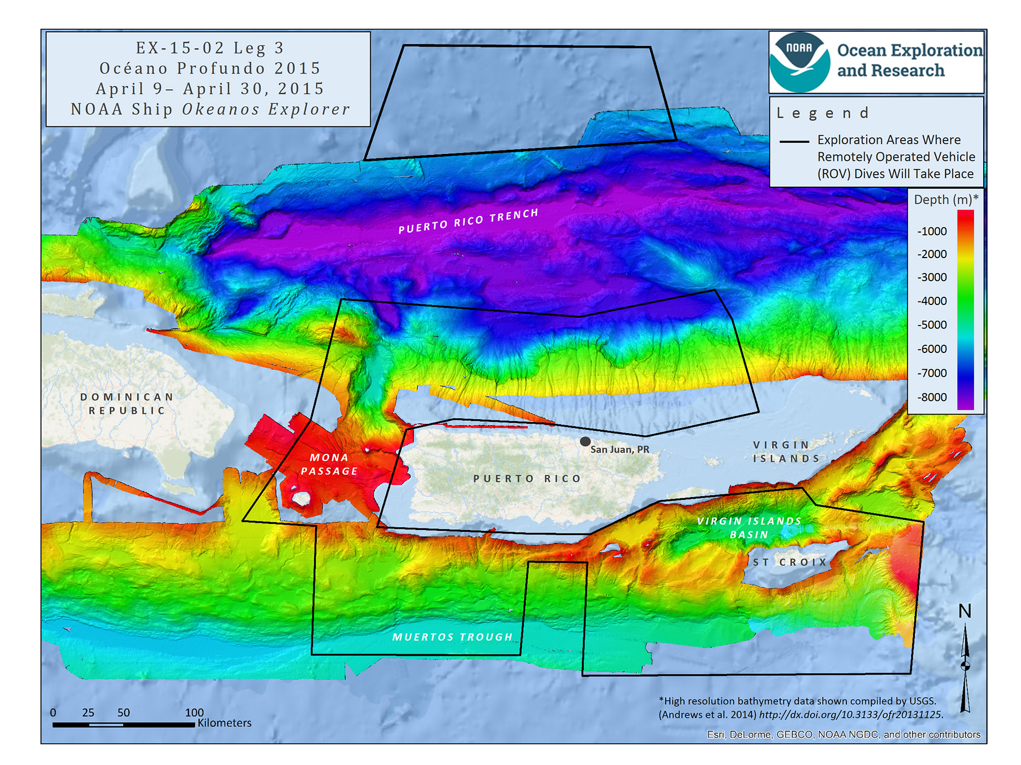
From April 9 to April 30, 2015, NOAA Ship Okeanos Explorer explored largely uncharted deep-sea ecosystems and seafloor in the vicinity of Puerto Rico and the U.S. Virgin Islands. What they found – using state of the art technology – will amaze you!
Quartz posted this incredible video to their Facebook page, using footage gathered from NOAA. Some of these creatures are so new – they don’t even have names.
Océano Profundo 2015
Legs 1 and 2 of the mission focused on mapping the seafloor where primarily only low-resolution satellite or topographic data existed previously. Leg 3 of the expedition featured some of the deepest remotely operated vehicle (ROV) dives ever conducted in the region and collected critical deep-water environmental data that will improve ecosystem understanding and inform federal and local resource managers.
Why Puerto Rico?
According to NOAA, a diversity of seafloor features lie just offshore Puerto Rico and the U.S. Virgin Islands that include trenches, seamounts, numerous submarine canyons, valleys, and troughs. These features likely contain valuable and vulnerable ocean resources, but very little is known about them, making this an important area to survey.
It is crucial to explore this area for several reasons:
It is tectonically active, with seismic hazards
It includes a large section of U.S. Exclusive Economic Zone
One of the major fisheries in the area is deepwater snapper, but little is known about snapper populations there
It is of potential interest for marine protected area managers, those creating ocean usage planning maps, and sanctuary managers
Mission map showing the operating areas, with priority areas outlined in black, for Leg 3 of Océano Profundo 2015: Exploring Puerto Rico’s Seamounts, Trenches, and Troughs. Map created with ESRI ArcMap software and data displayed is provided by ESRI, Delorme, GEBCO, USGS, NOAA NGDC, and other contributors. Image courtesy of NOAA Okeanos Explorer Program.
Communication Technology
NOAA did a fantastic job of documenting their journey, allowing scientists and the public access to mission logs, daily reports, photos, video, and live underwater video feeds.
During the dives, Okeanos Explorer’s two-body ROV system continuously captured high-definition video, which the ship transmitted to the Office of Ocean Exploration and Research’s website, www.oceanexplorer.noaa.gov, where anyone could follow along in near-real time!
NOAA Ship Okeanos Explorer uses telepresence technology to transmit data in real-time to a shore-based hub where the video is then transmitted to a number of Exploration Command Centers located around the country as well as to any internet enabled device. Access to the video and a suite of Internet-based collaboration tools allow scientists on shore to join the operation in real-time and allows the general public to follow along with the expedition. Image courtesy of the NOAA Okeanos Explorer Program.
Okeanos Explorer
NOAA Ship Okeanos Explorer, “America’s Ship for Ocean Exploration,” is the only federally funded U.S. ship assigned to systematically explore our largely unknown ocean for the purpose of discovery and the advancement of knowledge. Telepresence, using real-time broadband satellite communications, connects the ship and its discoveries live with audiences ashore. Visit the NOAA Marine Operations Center Okeanos Explorer page for operations and crew information 🙂
 The first operational dive of Okeanos Explorer’s 2016 season got off to a frightful start. At the end of February, NOAA’s remotely operated vehicle (ROV) Deep Discoverer dove 2 1/2 miles underwater to collect geological samples near Hawaii. While surveying the area, scientists were shocked to see a wispy white ghost-like octopod dance into view.